During the summer, I wrote about a surprise road trip I took with my mother in Cambridge. This curated road trip, created by Guess Where Trips took us to exciting and spooky places. I shared a little about our Historic Haunts tour, but I wanted to keep some of the details a surprise at the time, so I could share this ghost story and pioneer cemetery visit with you now, in October.
So today on the blog, I want to share a little bit more about my visit to the haunted Waterloo Pioneer Memorial Tower and Doon Pioneer Cemetery and explore its rich history.
While looking for places to go for a walk, the day before our Historic Haunts tour, I found a hidden gem that had everything we were looking for—a walking trail, a historic site, and a cemetery. Little did we know when we visited that it was also haunted!
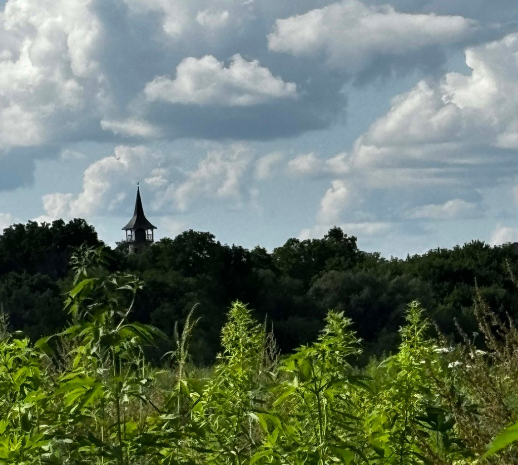
The Waterloo Pioneer Memorial Tower stands 18.9 meters tall, and peaks out above the surrounding trees. We could see its Swiss-style copper roof and the cute Conestoga wagon weather vane that sits atop it, as I parked my car in the nearby parking lot.1
The Tower built in 1926, was created to commemorate the arrival of the Pennsylvania-German pioneers who immigrated to the area between 1800 and 1803.1 Fieldstones that line the outside wall of the tower represent the tireless work they did to plow and clear the land for farms and homesteads.
At one time, it was possible to go inside the tower and climb its spiral staircase to the eight-sided observation deck. The view is amazing, as Bob Oberholtzer noted in a 2015 article for the Waterloo Region Record. Citing it as one of the most “historic views”, it’s possible to overlook the first four Mennonite farms that were settled in the area.2 Oberholtzer also talked about how they used to scare the girls who climbed the tower, not with ghost stories, but with childhood antics like shaking the stairs as the girls climbed up.2
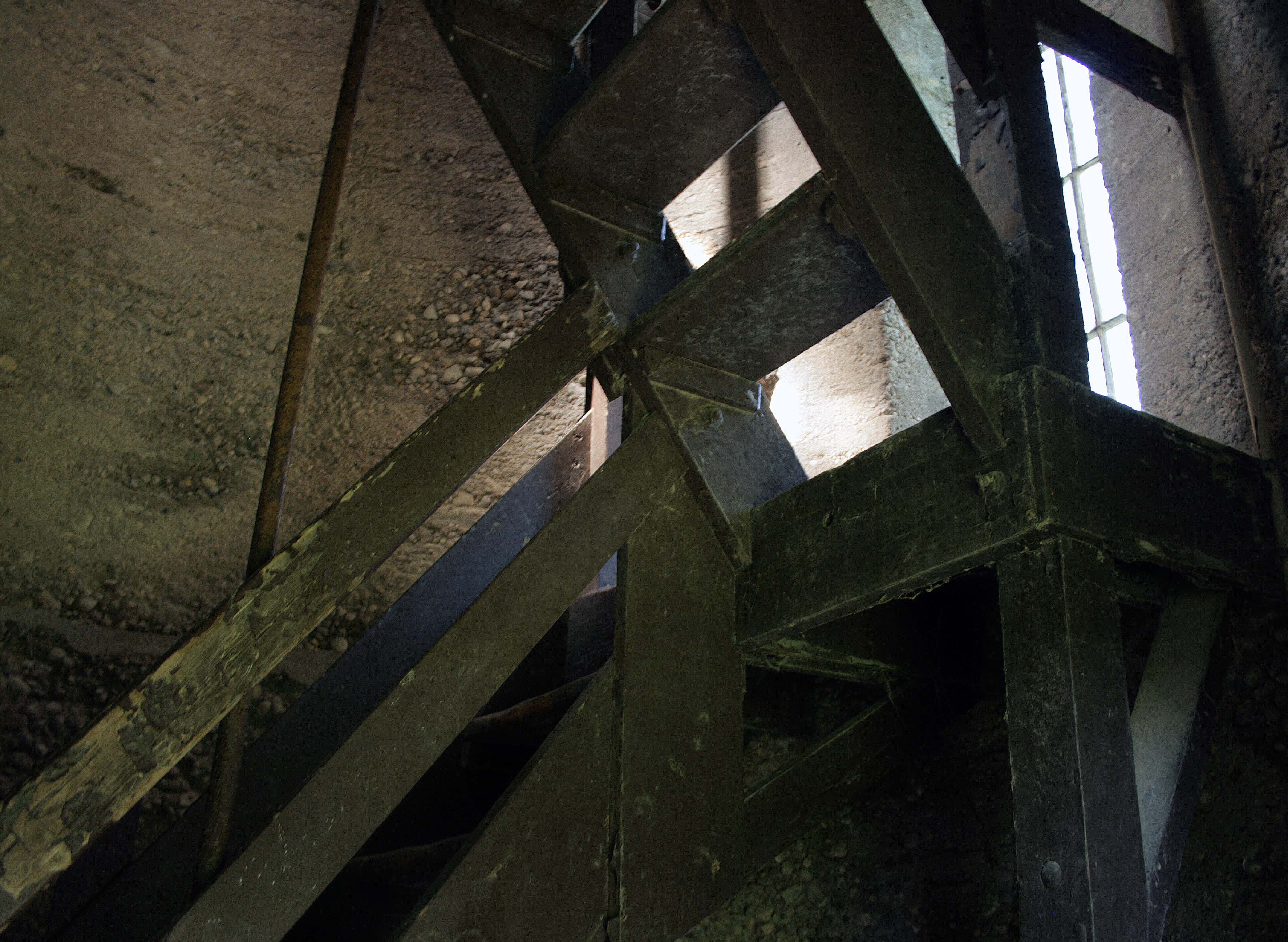
Although the tower has barely needed any repairs to keep it standing over the years, the tower has been closed to the public since 2008.2 BUT, it is possible to tour inside, by special request.2 A sign on site has a phone number that can be called to book a visit to the top of the tower. I wish I would have known this when we visited. We made do by peering through the gated doors to glimpse the cobwebs and spiral staircase inside.
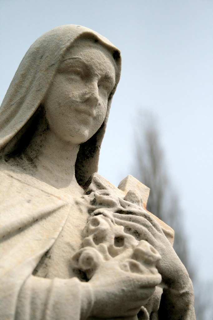
What we also didn’t know at the time of our visit, was the haunted history of the place. The story goes that a woman jumped to her death from the top of the tower. She was distraught and suffering from grief of the loss of her husband, who went off to war—but never returned.3
They say her restless spirit can sometimes be seen at the top of the tower, waiting for her lost love to return.3
Doon Pioneer Cemetery
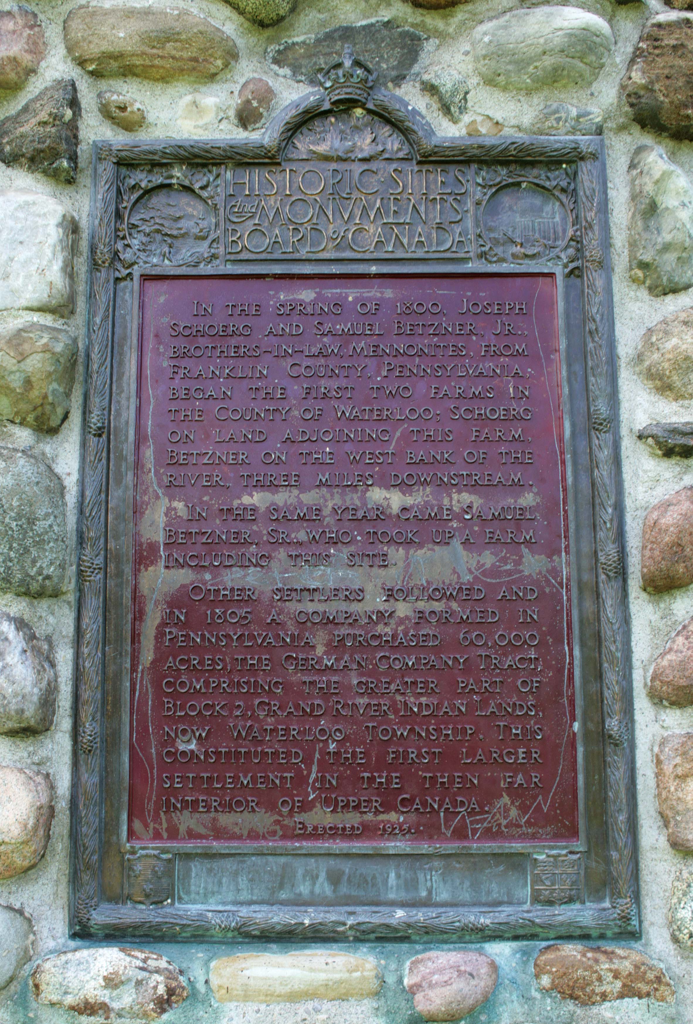
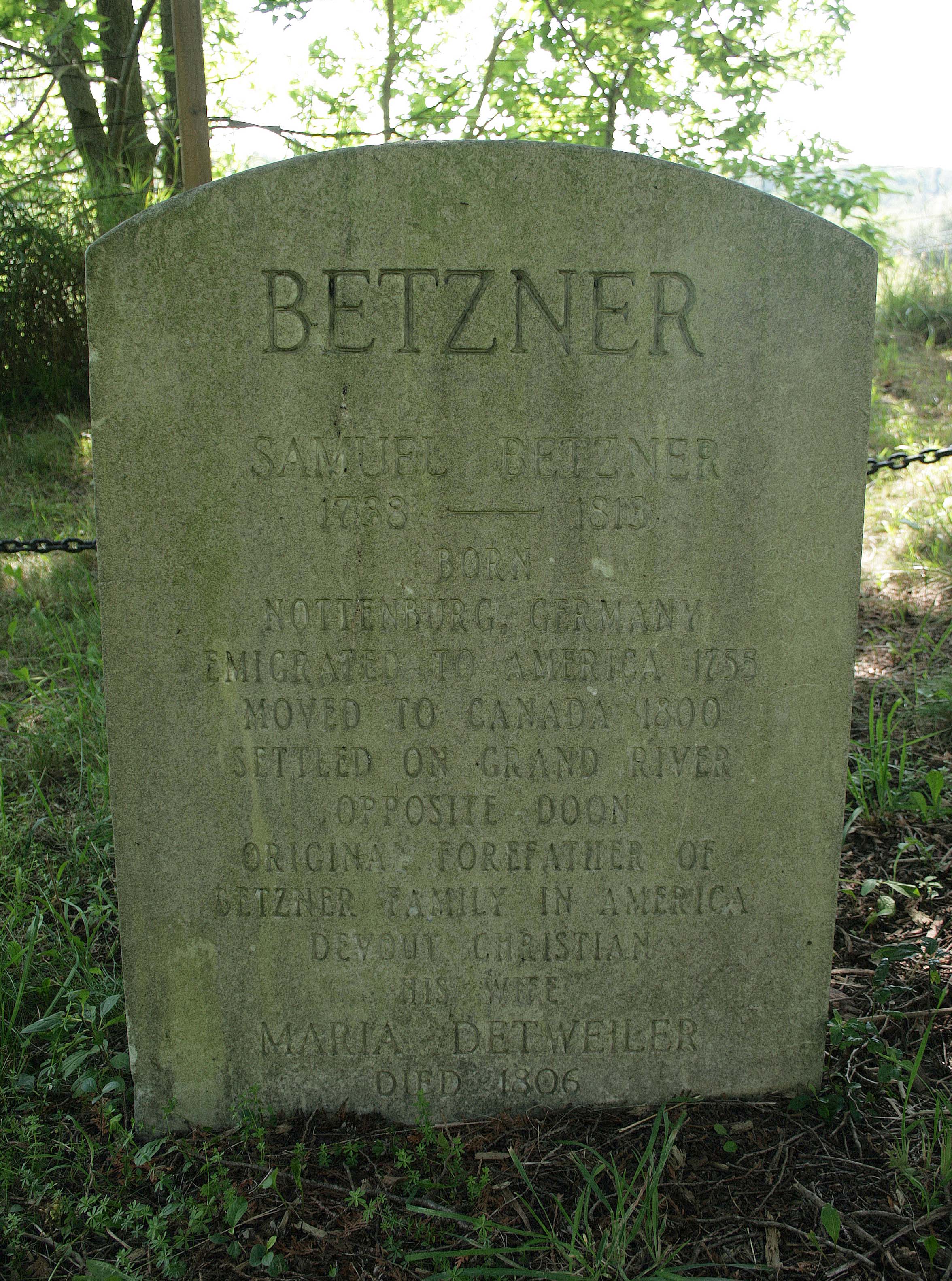
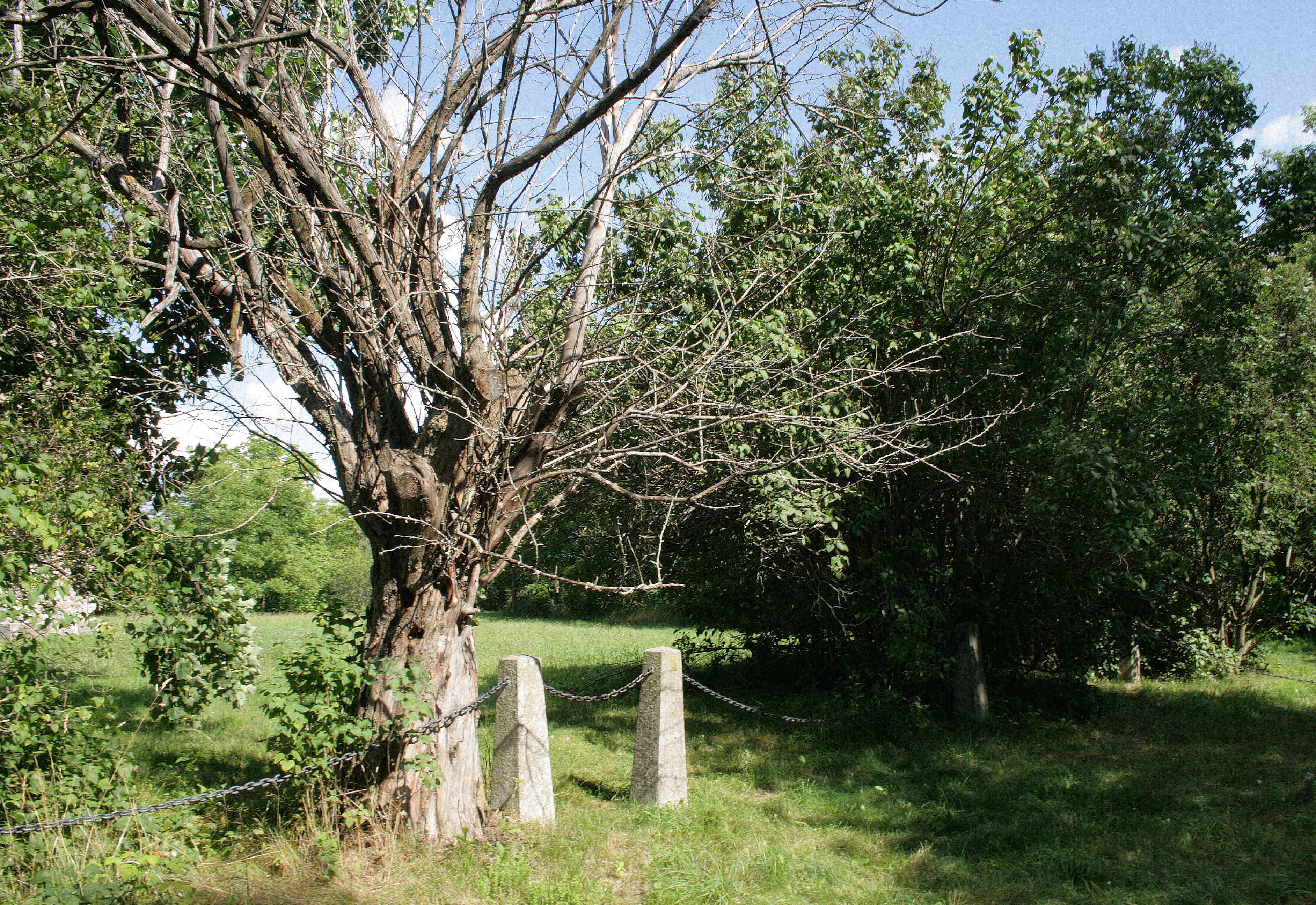
The 98-year-old Pioneer tower sits within a small grassy field, right beside the Doon Pioneer Cemetery. This is the final resting place of the Schoerg and Betzner families and overlooks the Grand River.
Also known as the Schoerg/Betzner cemetery, this small burial ground is where the first settlers are laid to rest, who arrived in Waterloo Township in the spring of 1800. The small cemetery is filled with old gravestones and field stones, marking their final resting place.
Some of the gravestones are very worn, so I took the opportunity to try out a trick I saw in one of the cemetery groups I am a part of. By using a mirror to reflect sunlight, or by holding a flashlight at an oblique angle you can create enough contrast to make gravestones legible again.
I had a small flashlight on me, one with a small beam so it worked well on the smaller stones. I asked my mom to hold the flashlight for me, as I lined up my shot by looking through the small viewfinder on my DLSR. The deep shadows help some of the long-forgotten words to be legible again. The flashlight trick didn’t work as well on larger stones, because the beam from the flashlight is too narrow to illuminate enough of the stone. I would need a much larger beam for that. This trick of the light is a great way to reveal gravestone inscriptions while doing no harm.
My mother and I both enjoyed visiting the memorial tower and the small burial ground beside it. We took our time taking in the beautiful craftsmanship and design of the tower and its history. At the time, we had no thoughts of ghostly apparitions in our minds. We didn’t experience anything supernatural. We just admired the Fieldstone Tower and all the toil and hard work it represented for those early pioneers.
After exploring the cemetery and paying our respects to the early settlers of the area, we made our way to the Walter Bean Grand River Trail. The flat gravel path meanders through the Pioneer Tower Natural Area taking you along the Grand River. The trail is dotted with educational panels, and the path eventually brings you to the Pioneer Tower Bridge.
On the opposite side of the bridge lies the Doon Valley Golf Course. On our walk, we didn’t cross but stopped at the bridge to take in the views. We sat for a time at a little garden roundabout, just before the bridge, admiring the flowers and wildlife. We were lucky to see a wild rabbit scurry across the trail.
The Memorial Tower was always in view during our walk, peeking out above the treeline like a sentinel keeping watch. A strong reminder of those who came before us. The whole area is beautiful, even more so now I imagine with the fall colors starting to emerge.
So if you are looking for a nice place to take in nature and enjoy some dark history, I think the Waterloo Pioneer Memorial Tower and adjacent Doon Pioneer cemetery would be a great place for a fall outing. Who knows, you might even see a ghost.
Summertime is meant for road trips! In July, I went on a two-week vacation full of adventures. One of the trips I was looking forward to most on my vacation was visiting Algonquin Provincial Park. Algonquin is Canada’s first Provincial Park, having been founded in 1893.1 It’s a large and beautiful piece of wilderness, that also holds a mystery.
My 80-year-old mother joined me on this camping trip. It had been about 40 years since she last went camping, so I made sure we did all the fun camping things; sleeping in a tent, cooking on a fire, and making s’mores. There were a couple of other things on our to-do lists: visit Canoe Lake, search for Mowat Cemetery, and find the grave of Tom Thomson.
The story of Tom Thomson is an interesting one. Today, he is often referred to as the Canadian Van Gogh.2 And rightly so, his use of color and thick strokes vividly bring the northern landscapes to life. Thomson spent a lot of time painting and fishing in beautiful Algonquin Park. His love of the area must have been contagious as he soon had other painters joining him on his painting excursions. They even had a name for themselves, the “Algonquin Park School of painters”.3 You might recognize them more now as the Group of Seven. Unfortunately, Tom wouldn’t live long enough to see that recognition as he died mysteriously, two years prior. I would consider him a founding member, of the now famous group of painters.
There have been many things written about what happened to Tom Thomson on that fateful day in July. But to this day, no one knows for sure what happened. With so many varying accounts over the years, speculating what may have happened, the details of the events don’t seem to add up. We do know that Tom’s canoe was found on July 8th, but he was not. His body was found in Canoe lake, 8 days later on July 16th.4 He was found with bad bruising on his face and head, with a fishing line wrapped around his left or right ankle, depending on which account you read. In most accounts, the fishing line is seen as an indication of foul play. I don’t agree. I have been doing a lot of reading about this mystery and one thing that always stands out to me is the fishing line.
Tom’s body was found floating in the lake. Many people speculate that something heavy was tied to the fishing line to weigh the body down, that he was purposely drowned. BUT all the accounts mention that the body was tethered to the shore, and not removed immediately from the water. I think it would make sense that they would have used a fishing line to tether the body to the shore, which would account for the fishing line. One blog post I found corroborates this thought, but for some reason has not been looked at more closely. The blog post comes from a professional journalist, Robert Reid. In his blog post, Epistles from the Grave, Robert talks about letters that were written in the 1970s by Jack Wilkinson. He would have been six years old at the time of Tom’s death. These letters were written to correct some inaccuracies in the accounts that were circulating, most notably the fishing line. In the letters, Wilkinson confirmed that the fishing line was merely used to tether the body to the shore, so it would not float away until the coroner could be alerted and come collect the body.5 This would mean the fishing line had nothing to do with Tom’s death. Still, the questions persist—was it murder? Or was his death an accident? These details we may never know.
Tom was hastily buried at Mowat cemetery, sometimes referred to as Canoe Lake cemetery. This is not what his family wanted. They wanted him brought home. So his remains were exhumed the next day and transported to Leith, Ontario, near Owen Sound. There his remains were buried once again, and a proper headstone was erected.1 Here lies another facet of the mystery—many people claim his body was never moved.
Is that why people also claim to see a ghost in the early morning fog on Canoe lake? Over the years, many people have reported seeing a man slowly paddling a distinctive grey canoe through the still waters of the early morning.6What’s interesting about these sightings is that in life Tom Thomson had painted his canoe a unique dove-grey color, that he had mixed himself from his paints. This dove-grey canoe stood out among the identically colored canoes of the local lodges.1 Unfortunately, I was not able to find anyone in the park who had experienced any sightings firsthand.
Our search for his grave began on the morning of July 17th, which just so happened to be the 105th anniversary of Tom’s burial at Mowat Cemetery. We drove into Algonquin Park that morning, and after stopping in to check on our campsite at Tea lake, we decided to try and find the cemetery. I had been planning this trip since the early spring of this year and had been researching how to find the hidden cemetery. In early June, Back Road’s Bill, a local adventure/nature writer, published an article about the two graves of Tom Thomson, so I reached out to him about directions for reaching the cemetery. He was very helpful. With the coordinates locked into my Google Maps, I felt pretty confident that we could reach the cemetery.
That confidence wavered a little though when we visited the Canoe Lake Access Point Permit Office. We stopped in, after taking in the view of the infamous Canoe Lake, to buy some firewood and talk to the staff. The clerk was a young man, who had just started working at the permit office. He didn’t have any personal stories to share about the haunting of canoe lake but did have some interesting ideas about where Thomson may actually rest. He shared an interesting theory that the gravedigger that was hired to move the body had sent a coffin filled with dirt and rocks to the family, to approximate the weight of a body. He also told me that the cemetery can only be accessed by canoe and that the back roads I had pointed out are actually the train line, not a road. I was a little dismayed, but I had faith in Back Roads Bill and his map, so we continued on.
And good thing we did! The rail line the Permit office staff talked about was now a camp road. We followed it as far as we could, safely by car. At one turn-off the road became quite rough so we decided to park the car on the side of the road and continue on foot. This would turn out to be our hike for the day. It was a very nice walk in the lush woods of Algonquin Park. After walking for a time, we came upon some cottages on the lakefront. One cottage had a large family gathering outside, so we stopped and asked them for directions to make sure we were on the right path. They assured us we were and gave us some landmarks to go by, as there is no sign marking the cemetery. We continued on our way, trying to align ourselves with Canoe lake, and picture what it would look like to travel the route by canoe. We couldn’t easily see the lake. Unfortunately, the landmarks the cottagers gave were not the most helpful and we got a little turned around.
For an area that seems incredibly remote, there are a fair number of family cottages out there. We happened upon another cottage where it looked like they were packing up to go home. We asked again for directions. The gentleman we had asked was kind enough to walk with us to the entrance of the cemetery trail. We had gone a bit too far, having stayed to the left when we should have taken a right at the fork in the trail. His german shorthaired pointer puppy joined us, zooming back and forth past us as we walked. He told us how that day was the anniversary of Tom’s burial and how his family sometimes walked up to the cemetery to pay their respects. He didn’t have any ghost stories to share though. He brought us to the start of the cemetery trail, a small almost hidden trail that veers again to the right off of the bigger trail. We thanked him and continued on our way. This part of the trail was more rugged, with felled trees and a faint trail that was sometimes hard to distinguish in the wild forest. My mother said she was starting to have doubts at this point in our adventure, but those doubts faded when we came to a hill.
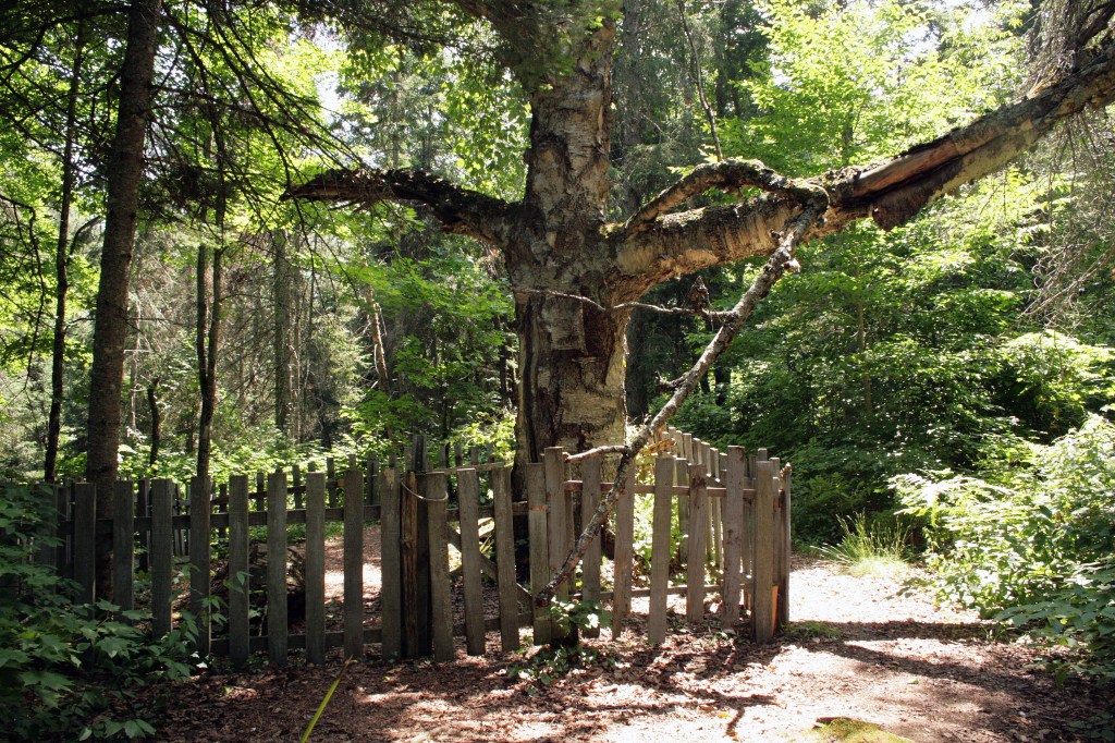
Sitting at the top of the hill we could see an old weathered fence and the supposedly 500 year old birch tree. It’s the largest birch tree I have ever seen! We happily climbed to the top and walked into Mowat cemetery. This small pioneer cemetery is a small remnant of the town of Mowat. This mill town was the largest in Algonquin Park and had about 500 residents in its heyday. The town included a hospital and school, as well as recreational lodges. Tom Thomson often frequented Mowat Lodge. The town began to dwindle, after the lumber recession.7 Today, all that remains of Mowat is the cemetery and a few cement foundations.
The cemetery is very small, with only a handful of grave markers. There is one field stone, and two engraved headstones within the picket fence. There is also a white wooden Latin cross, that marks the grave of Tom Thomson. It is thought that the cross was placed by the CBC in the 1960s for a documentary. There also seems to be a depression in the ground at his grave. There were a few grave goods left for Tom; a small electric tea light, some paint brushes and a fishing lure. There was no one at the cemetery when we visited, but I think Tom still receives his fair share of visitors.
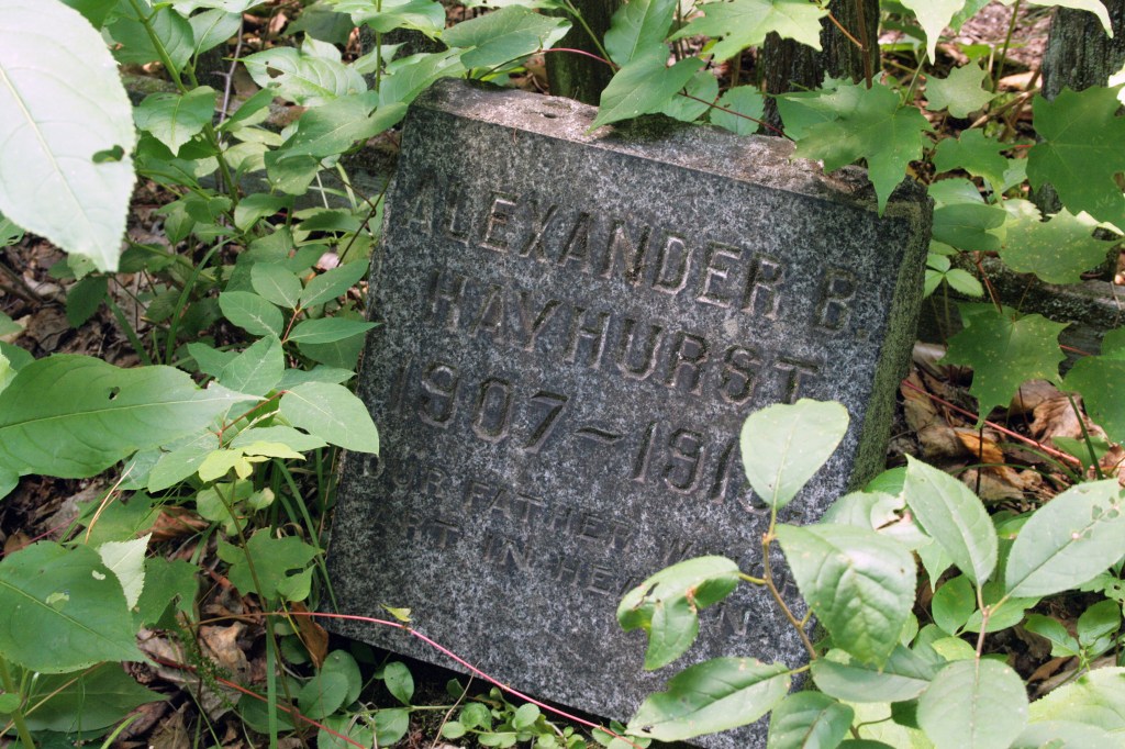
There is also a large flat gravestone for Ja’s Watson who is thought to be the first person buried at Mowat Cemetery. His stone is hardly legible now, but records say that the epitaph reads:
“In Memory of Ja’s Watson / The First White Person Buried / at / Canoe Lake / Died May 25 1897 being one of / about 500 employed at this Camp by / the Gilmour Lumbering Co. Aged 21 yrs / Remember Comrades (when passing by) / As you are now so once was I / As I am now so you shall be / Prepare thyself to follow me.”8
We spent a lot of time in the cemetery, trying to decipher the stones and admiring the enormous birch tree, and paying our respects to Tom Thomson. We tried to imagine what the cemetery would have looked like in 1917 when he was laid to rest. After a time we decided to head back down the hill and retrace our steps back to the car. It was a bit of a long journey, but it was incredibly rewarding. Back at our campsite we had a nice campfire supper of burgers and corn on the cob and talked about our visit to Mowat cemetery. We speculated on what might have happened to Tom and whether or not he was still laid to rest on that hill. My mother was very adamant that he was still there. After supper, we made some s’mores for dessert and enjoyed the campfire as it lit up the darkness of the night.
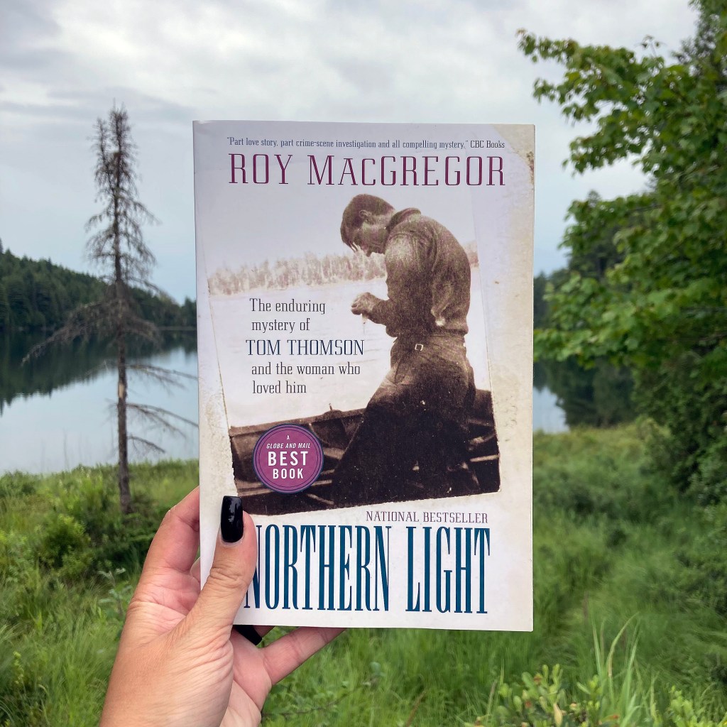
The next morning we decided to explore the park a little more before heading home. We stopped in at the Algonquin Art Centre to look around. This world-class art gallery showcases some of Canada’s foremost wilderness and wildlife artists.9 Outside, on the Centre grounds, we took a look at a set of plaques celebrating Tom Thomson. They told the story of Thomson as a painter, his attraction to Algonquin Park, his body of work, and his legacy as an artist. We also viewed an outdoor exhibit of painted canoes, called Tom Thomson’s Canoe Murals. We spent some time inside the gallery as well, taking some time to admire the gorgeous art gallery and browsing the gift shop. This is where I purchased my copy of Northern Light by Roy MacGregor.
Northern light: The enduring mystery of Tom Thomson and the woman who loved him by Roy MacGregor
Northern light: The enduring mystery of Tom Thomson and the woman who loved him by Roy MacGregor is a very good read. It presents some really interesting theories as to what may have happened to Thomson, and also suggests that his body never left Mowat Cemetery. In the 1950s, a small group of men took it upon themselves to prove whether Tom was still buried in the cemetery on Canoe lake. They took some shovels, went up to the cemetery, and started digging. I think to even their surprise, they did find human remains. They took a few bone samples, including the skull, and sent them for analysis. The results were not what they expected and seemed to raise more questions.1 More recently, a facial reconstruction was attempted using photographs of the unearthed skull. The face that emerged was pretty uncanny, but does that mean the mystery is solved?10
I don’t think the mystery will ever truly be solved. I believe the truth of what happened to Tom Thomson went to the grave a long time ago. But that doesn’t mean people will stop trying to solve it. Stories will continue to be told about his tragic life, cut short. As much as Algonquin Park was a part of Tom’s life, his artwork is now a part of it as well. You can find his artwork at the Art Centre. You can see the inspiration for his art in the beauty of the wilderness. You can learn more about his life in the Visitor Centre, alongside the history of the land and the evolution of the communities within the park. Tom Thomson, whether it be his artwork, his story, or his ghost will continue to be a big part of Algonquin Park.
I really enjoyed my time exploring the park and searching for the grave of Tom Thomson. It was a rewarding trip, that let me explore nature while also learning more about art and Canadian history. It was one of the more challenging cemeteries to find, but it was a beautiful place to visit and photograph. My mother enjoyed this trip immensely. She was a bit leery at first, but the history drew her in. She talks about our trip often. Coincidentally, I started writing this blog post on what would have been Tom’s 145th birthday, August 5th, 2022. My mother shares his birthday.
Have you ever been to Algonquin Park? Have you seen the ghost of Tom Thomson? I would love to read your stories in the comments. If you are interested in reading more about the mysterious death of Tom Thomson, check out the links below.
Thanks for reading!
References:
MacGregor, R. (2010). Northern light: The enduring mystery of Tom Thomson and the woman who loved him. Vintage Canada.
A couple of weekends ago I was able to cross something off my cemetery bucket list—visiting all 25 cemeteries in the care of the City of Greater Sudbury. For today’s blog post, I thought it might be interesting to take a closer look at some of these cemeteries.
The City of Greater Sudbury is centrally located in Northeastern Ontario. It sits on the Canadian Shield in the Great Lakes Basin and is composed of a combination of urban, suburban, rural, and wilderness environments. Greater Sudbury is 3,627 square kilometers in area, making it the largest municipality in Ontario, geographically.1 Making up this municipality are many small communities that over time, have been amalgamated into the City of Greater Sudbury. Almost all of these little communities have their own cemeteries, that now fall under the care of the city.2
Each of these cemeteries has their own charm and has been very interesting to visit. Some are newer cemeteries with very modern stones, that are still very active, like Valley East and Park Lawn cemeteries. Some of them have tombstones marking persons who are still living. Those always make me think—do the owners visit their gravestones? Other cemeteries are pioneer cemeteries, like Ruff Pioneer Cemetery. Those types of cemeteries hold a lot of history. I wrote about my visit to the Ruff Pioneer Cemetery, you can read it here.
Two of the oldest of these cemeteries, I believe, are the Eyre and Anglican cemeteries. They are directly beside each other, and there is no distinct line to separate the two. The earliest grave is from 1890.3 Both of these cemeteries can tell you a lot about our city. You can find the namesakes for the Gatchell and Lockerby areas of town, as well as the grave of Frederick J. Eyre, who discovered one of the first mines for the Canadian Copper Company.3 Sudbury, at its roots is a mining and railroad town.
Some of these cemeteries were a challenge to find and can be hard to access. Ruff Pioneer Cemetery would be more easily accessible with a four-wheeler. Make sure you have plenty of water with you for that adventure in the woods. The Coniston Cemetery is a little bit more accessible now, as a cemetery trail has been created, linking it to the Jean Tellier hiking trail. The first time I visited that one, we searched for a while before deciding to ask for directions from some locals at a convenience store. They were more than happy to help and even drew me a map. They also shared some stories from their childhood, of how they would play in the cemetery and nearby woods. Coniston Cemetery is particularly interesting because there are no more headstones. There may have originally been wooden markers or fieldstones there that have since deteriorated or have been moved. It was an active cemetery from 1914 to 1926, when the parish that was taking care of the cemetery announced they could no longer do so.4In 1997 a memorial plaque was installed honoring the deceased known to have been buried there. Another hard-to-find cemetery is the Wahnapitae Public Cemetery. This one is located on a hillside with seemingly hidden access. I tried to find it again recently, but with no luck.
There are a few cemeteries on this list that I have visited many times, either due to their size or proximity to me. Lasalle Cemetery for instance is one of the largest cemeteries in the area. So large in fact that every time I have visited I have focused on a different section to photograph. Another large one, that just so happens to be down the street from me, is Civic Cemetery. This is an active cemetery, and I think has changed the most over time. It has a large columbarium, as well as some lovely winding paths. It’s a lovely rural cemetery. I have many friends of the family that are buried here.
I have enjoyed seeking out all these cemeteries. I feel like I can now say that I have truly explored my city. All these cemeteries hold small threads, connections, that all lead to the creation and growth of my hometown. I have learned a lot about the history of Sudbury, like the stories of some of its founders, the history behind street names, and much more. I would love to spend more time in some of them, to fully explore the grounds, look for specific graves and to see what else I can learn.
Thanks for joining me, as I look back on this bucket list milestone. Do you have a bucket list? What’s on your list? I would love to read about it in the comments.
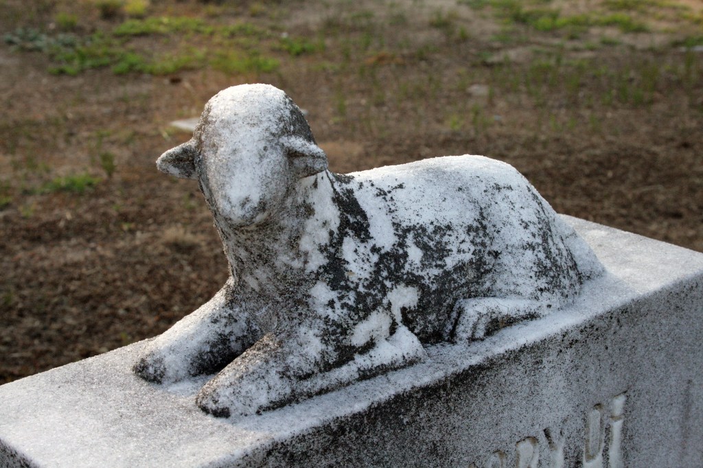
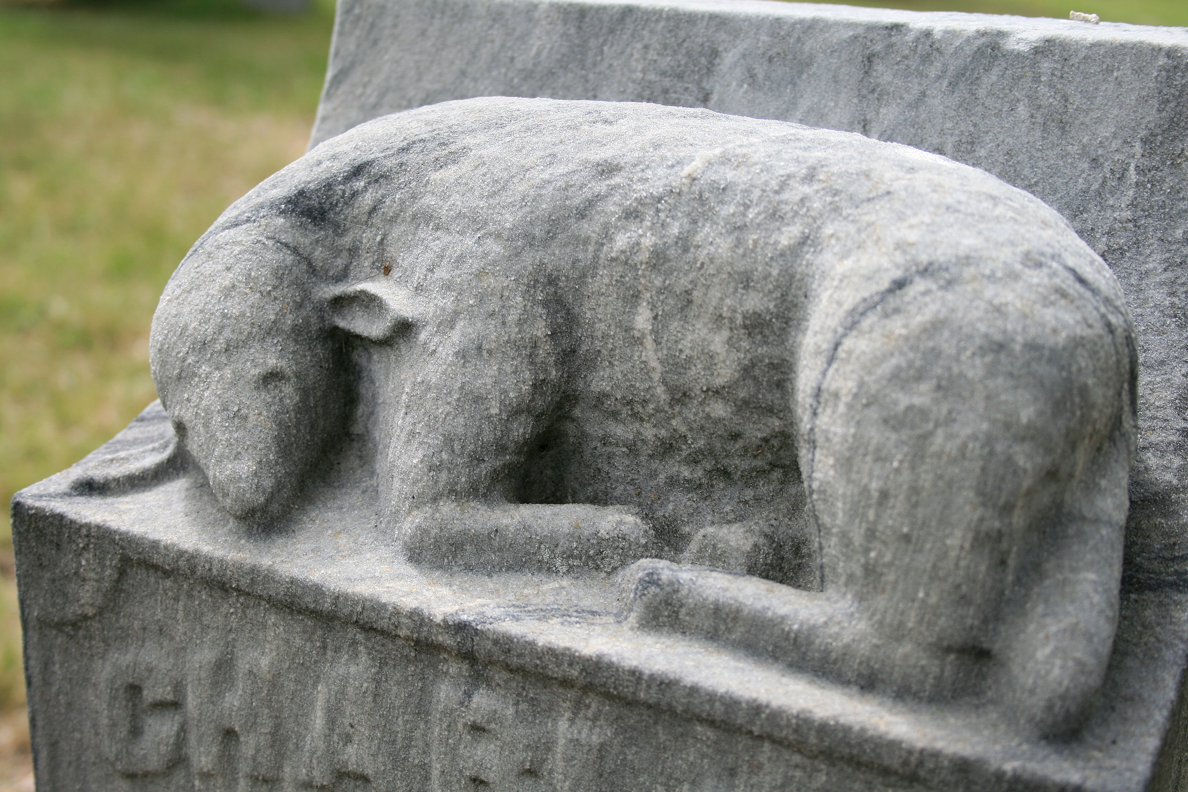
I love exploring cemeteries and looking at the different symbols used on tombstones. If you spend a lot of time in cemeteries, especially in Northern Ontario, you will start to notice the repetition of certain symbols and motifs. One of the most common symbols I find, is the lamb.
Lambs represent innocence and sacrifice, as they were often used in sacrificial ceremonies in ancient times1. Most often you will find lambs on the gravestones of infants and children, as Jesus is often depicted as a Shepherd, and also known as the “lamb of God”. Some variations can be found with lamb symbolism. A robed figure with a standing lamb beside it most often represents John the Baptist, who had called Jesus the “lamb of God”1. A lamb with a cross is known to represent the Lamb of God or Agnus Dei2, symbolizing the suffering of Christ as he sacrificed himself for the sins of mankind. Several other symbols may be found with a lamb to symbolize the lamb of God – such as a banner, halo, shepherds crook, and alpha and/or omega symbols2. A single seated lamb symbolizes an innocent soul. A seated lamb can sometimes be found sitting in front of a tree stump, this often symbolizes a life cut short.
Finding lambs is often sad, but they are a beautiful symbol. I have photographed many over the years and wanted to share some of them with you today.
In August of 2020, a friend and I set out to find an abandoned cemetery. She had been to it before, having stumbled upon it while out and about on four-wheelers. She was excited to share it with me. She and I have been on many cemetery adventures, but this one was a bit different for us. Normally we would jump in the car and head for a destination while stopping at all the cemeteries we found along the way. This one was a bit closer to home and would need to be reached on foot. So with the camera in hand, we started walking. Have you ever seen the movie Stand by me? It sort of had that feeling, except we weren’t going to see a dead body, we were off to see a cemetery.
Happy Valley is considered a ghost town. According to Ontario Abandoned Places, it never really was considered a town at all.
“…more of a settlement which belonged to Falconbridge. Happy Valley consisted of residents who wanted to be separate and independent from the residents of Falconbridge…The residents were mainly farmers and mill-workers who worked at the sawmills by the lake. The children would have to endure a three-mile walk every morning to the nearest school (established in 1907) located in Garson…Other than the mills and homes, there were no stores or a post office to be found. Residents had to travel to Falconbridge Township for amenities…By 1970, the town was abandoned…almost. The last resident, “Gizzy”, left the town in the late ’80s.” – Ontario Abandoned Places
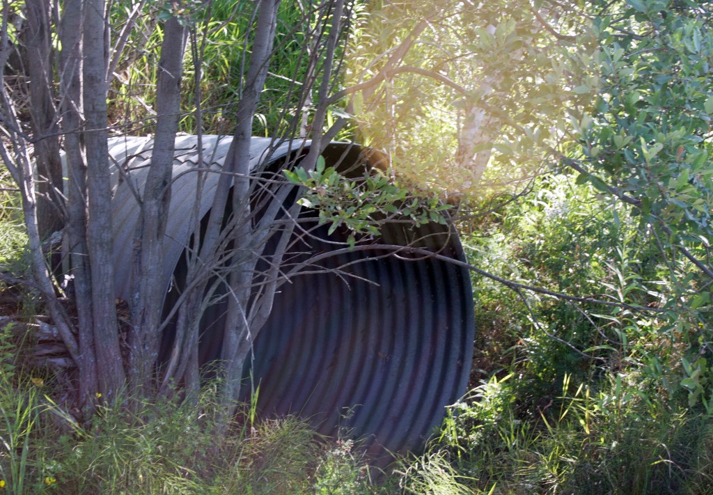
Our trip began by taking us into a more industrial part of the town. There were dunes everywhere and an old abandoned railway track. Small trees and bushes were growing from in between the railway ties. Those tracks had not seen much use in a while. We walked the train tracks for a little bit, but then found a dirt trail that took us more into the surrounding wilderness. We passed old culverts and a few small lakes. It was a beautiful day for a walk!
The way to this cemetery wasn’t a straight shot, or well marked. We had a general direction and were using landmarks to help find our way. We referenced old photos from the first time my friend had been there. We seemed to have made our way into some backcountry, where there were sandy trails and lots of sandy hills, that would be great for four-wheeling. After climbing up into a rocky area we reached a plateau where it levelled off and there was a two-lane sandy road. It was nice to not have to watch our footing anymore for fear of catching a toe on a rock.
My friend felt we were getting close. We walked on, enjoying each other’s company and chatting about life. Now and then we would stop to assess how far we had gone. We were alone in the woods, having not seen anyone else out on the trails. After a while, we started to question if we had gone too far. We checked a side trail, but no, it was going off in the wrong direction. We took a small break to rest and re-evaluate. Luckily, we still were getting cell service in what seemed like the middle of nowhere. She was able to look at satellite photos on Google and find what looked to be our cemetery. We had gone too far! We had to backtrack a little way and take a dirt road that forked to the right. Our goal should be right around that corner.
We found it! It’s a small cemetery, having been recently surrounded by a chain-link fence. We theorized that the fence was put up to protect the cemetery from people unintentionally running through it on quads and snowmobiles. There are about a handful of headstones, some up-right and a few flat to the earth. There seem to be more pioneers buried there than there are headstones.
Having found the cemetery and being able to visit it was well worth the hike. It was super satisfying! Almost more rewarding than if we would have driven straight there. After spending some time among the tombstones, we made our way back the way we came. Through the woods, along the dirt paths, and along the train tracks, ending by having to climb back up a massive dune that we had first scaled down at the beginning of our journey. It was a great adventure! I am grateful that I have good friends who want to share these kinds of experiences with me!
More recently, I was doing some pre-emptive cemetery road trip research, getting ready for this spring. I was going through all the cemeteries listed in my hometown, there are 25 in total. I have been to all but 3 of them, or so I thought. Based on my archived photos I had not visited Ruff Pioneer Cemetery, Chelmsford Protestant Cemetery, and St. Joseph Cemetery. As I did a bit more research into where these cemeteries are located, I got stuck on Ruff Pioneer Cemetery. It’s listed as being off of Goodwill Road, in Garson. As I searched Google Maps, it just was not making sense. I was able to zero in on its location using satellite photos. Low and behold—Ruff Pioneer Cemetery is our Abandoned Happy Valley cemetery!
Looking back at my photos, though, it all makes sense!
Looking back at this cemetery adventure has me pining for summer and the opportunity to visit new cemeteries. I have a few road trips already planned and mapped out, but I may take a look for more abandoned cemeteries that are harder to find. Do you have a story about an abandoned cemetery? Share it in the comments!